
Danni’s guidebook
Food scene
Good choice for Breakfast, Lunch and Dinner. Mom and Pop type diner food with extra flare. The most popular restaurant for locals with a casual atmosphere. This restaurant does a lot to support our community in donating meals to those less fortunate.
A great meat lovers pizza too!
27 當地人推薦
Smoky Mountain Diner
70 Lance AveGood choice for Breakfast, Lunch and Dinner. Mom and Pop type diner food with extra flare. The most popular restaurant for locals with a casual atmosphere. This restaurant does a lot to support our community in donating meals to those less fortunate.
A great meat lovers pizza too!
Iron Horse restaurant offers an upscale atmosphere located in an historic inn dating from 1929. Great house salads and prime rib specials too!
61 當地人推薦
Iron Horse Station
24 Andrews Ave SIron Horse restaurant offers an upscale atmosphere located in an historic inn dating from 1929. Great house salads and prime rib specials too!
The Tavern is a favorite of locals and visitors alike. It has extensive outdoor seating on a screened
porch overlooking Spring Creek. They serve burgers, fish and chips, pizzas, craft beer, and jalapeno
poppers.
41 當地人推薦
Spring Creek Tavern
145 Bridge StThe Tavern is a favorite of locals and visitors alike. It has extensive outdoor seating on a screened
porch overlooking Spring Creek. They serve burgers, fish and chips, pizzas, craft beer, and jalapeno
poppers.
Hot Springs first craft brewery that includes outdoor seating! Taco's are the only Menu choice.
35 當地人推薦
Big Pillow Brewing
25 Andrews Avenue NorthHot Springs first craft brewery that includes outdoor seating! Taco's are the only Menu choice.
Currently serving a daily hot soup and hand-made sandwiches to go! You will find fine wines and local
craft beer, coffee, soda waters, tonic and kombucha! They also have a small grocery section with
gourmet frozen foods, Thai dishes, ice cream, homemade pimento cheese, local meats, vegan
protein, charcuterie, cheeses, seafood, crackers, canned delicacies: squid, clams and cockles,
sweets, fermented foods and homemade pimento cheese!
21 當地人推薦
Vaste Riviere Provisions, LLC
158 Bridge StCurrently serving a daily hot soup and hand-made sandwiches to go! You will find fine wines and local
craft beer, coffee, soda waters, tonic and kombucha! They also have a small grocery section with
gourmet frozen foods, Thai dishes, ice cream, homemade pimento cheese, local meats, vegan
protein, charcuterie, cheeses, seafood, crackers, canned delicacies: squid, clams and cockles,
sweets, fermented foods and homemade pimento cheese!
Great Burgers, Fries and Milkshake Restaurant.
Location : 13075 NC 209 Hwy, Hot Springs, NC 28743 (Community center building) 828-622-0001 www.daves209.com
Indoor and outdoor seating
17 當地人推薦
Dave’s 209
13075 NC-209Great Burgers, Fries and Milkshake Restaurant.
Location : 13075 NC 209 Hwy, Hot Springs, NC 28743 (Community center building) 828-622-0001 www.daves209.com
Indoor and outdoor seating
Shopping
Bluff Mountain Outfitters: Hiking and outdoor equipment (tents, backpacks, sleeping bags, stoves, etc.); clothes, accessories books, toys, gifts, natural foods, hiking foods, and cold drinks.
27 當地人推薦
Bluff Mountain Outfitters
152 Bridge StBluff Mountain Outfitters: Hiking and outdoor equipment (tents, backpacks, sleeping bags, stoves, etc.); clothes, accessories books, toys, gifts, natural foods, hiking foods, and cold drinks.
Gentry’s Hardware: Family owned since 1946, Gentry’s is an old-timey hardware store. Services include key cutting, chainsaw sharpening, glass cut etc.; general hardware and heating supplies, housewares, fishing, camping, & garden supplies. Large selection of knives, tools, plumbing/electrical supplies.
16 當地人推薦
Gentry Hardware
124 Bridge StGentry’s Hardware: Family owned since 1946, Gentry’s is an old-timey hardware store. Services include key cutting, chainsaw sharpening, glass cut etc.; general hardware and heating supplies, housewares, fishing, camping, & garden supplies. Large selection of knives, tools, plumbing/electrical supplies.
Artisun Gallery and Cafe: Browse through the gallery of local artists while grabbing a coffee, chocolate, drinks, baked goods, and ice cream also represent our passion for our local region.
29 當地人推薦
Artisun Gallery and Cafe
16 Andrews Ave SArtisun Gallery and Cafe: Browse through the gallery of local artists while grabbing a coffee, chocolate, drinks, baked goods, and ice cream also represent our passion for our local region.
Hillbilly Market & Deli
43 NW 25/70 Hwy, Hot Springs, NC 28743
828-622-3532
Visit our Grocery & Deli for fresh cut meats, fresh produce, jams & jellies, local made breads, pies, cakes, fresh made subs, pizza, hot dogs, BBQ.
Fresh made subs and sandwiches, soft serve ice cream, fresh meats and vegetables.
18 當地人推薦
Hillbilly Market
43 US-25Hillbilly Market & Deli
43 NW 25/70 Hwy, Hot Springs, NC 28743
828-622-3532
Visit our Grocery & Deli for fresh cut meats, fresh produce, jams & jellies, local made breads, pies, cakes, fresh made subs, pizza, hot dogs, BBQ.
Fresh made subs and sandwiches, soft serve ice cream, fresh meats and vegetables.
Trust General Store & Café
14535 NC-209General Store, Gas, Food and Snacks.
Neighborhoods
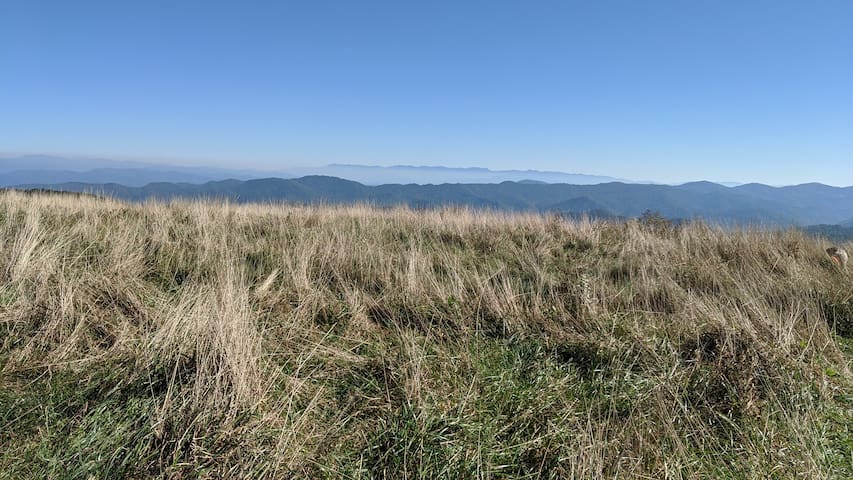
Max Patch Bald
A 4,700-ft. bald mountain was cleared and used as pasture in the 1800s. Today, it's a 350-acre
tract of open land on a high knob with 360-degree views. It's one of the most spectacular
settings you'll experience in the Blue Ridge. On a clear day, see from Mt. Mitchell on the east
to the Great Smoky Mountains on the south. What a picnic spot! And great for star gazing and wildflowers. The summit is a short uphill hike from the parking area deep in
Pisgah National Forest This is a great spot for a picnic!!!
Two easy loop trails lead you to, and around, the summit. The 1.4-mile short loop crosses the
summit. The 2.4-mile loop circles the mountain for outstanding views from all the sides. The
options are not marked, but it's hard to get lost atop the bald. From the parking lot, follow the
trail to the left to ascend around the base of the mountain, through a forest, crossing the top.
Or head up the steeper wider trail straight ahead. You can also hike north or south on the
Appalachian Trail for as far as you want. Hot Springs is about 20 miles north.
6 當地人推薦
Spring Creek
Max Patch Bald
A 4,700-ft. bald mountain was cleared and used as pasture in the 1800s. Today, it's a 350-acre
tract of open land on a high knob with 360-degree views. It's one of the most spectacular
settings you'll experience in the Blue Ridge. On a clear day, see from Mt. Mitchell on the east
to the Great Smoky Mountains on the south. What a picnic spot! And great for star gazing and wildflowers. The summit is a short uphill hike from the parking area deep in
Pisgah National Forest This is a great spot for a picnic!!!
Two easy loop trails lead you to, and around, the summit. The 1.4-mile short loop crosses the
summit. The 2.4-mile loop circles the mountain for outstanding views from all the sides. The
options are not marked, but it's hard to get lost atop the bald. From the parking lot, follow the
trail to the left to ascend around the base of the mountain, through a forest, crossing the top.
Or head up the steeper wider trail straight ahead. You can also hike north or south on the
Appalachian Trail for as far as you want. Hot Springs is about 20 miles north.
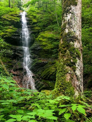
Harmons Den Little Fall Branch Falls - waterfall and hiking trails – you might consider
combining this trip with Max Patch
Once you’re going up Meadow Fork Road, go 5 miles and turn right
onto Little Creek Rd. and then go a half mile and turn right onto Poplar Gap Rd. Continue for
about 4 miles and turn right back on to Little Creek Rd. Go about a mile and make a slight left
onto Max Patch Rd (State Route 1182 - opposite direction of Max Patch) and go about 2 – ½
miles until you see the Harmon Den picnic area on the Left. Go past the Harmon Den Picnic
area and you’ll see a Horse Camp on the Left with a gate. Go past the Horse Camp until you
come to the next gate on the Right. Park without blocking the gate. The Trail leading to the
waterfall is on the Left before getting to the gate on the right. The trail fallows along the Little
Fall Branch creek. Last time we visited it was marked by pink flagging tape. The trail is easy
and leads to a 40-foot waterfall. It may not look to much like a waterfall during drought
conditions.
6 當地人推薦
Spring Creek
Harmons Den Little Fall Branch Falls - waterfall and hiking trails – you might consider
combining this trip with Max Patch
Once you’re going up Meadow Fork Road, go 5 miles and turn right
onto Little Creek Rd. and then go a half mile and turn right onto Poplar Gap Rd. Continue for
about 4 miles and turn right back on to Little Creek Rd. Go about a mile and make a slight left
onto Max Patch Rd (State Route 1182 - opposite direction of Max Patch) and go about 2 – ½
miles until you see the Harmon Den picnic area on the Left. Go past the Harmon Den Picnic
area and you’ll see a Horse Camp on the Left with a gate. Go past the Horse Camp until you
come to the next gate on the Right. Park without blocking the gate. The Trail leading to the
waterfall is on the Left before getting to the gate on the right. The trail fallows along the Little
Fall Branch creek. Last time we visited it was marked by pink flagging tape. The trail is easy
and leads to a 40-foot waterfall. It may not look to much like a waterfall during drought
conditions.
Hiking
Rocky Bluff Camp Ground
Directions from the farm: Turn left onto Highway 209 and go 3 miles and the camp ground will be on your right. It
is closed now but you can park at the entrance and walk into the campground and there are
three trails, the Spring Creek Nature Trail (1.2 miles) circles the campground, Spencer’s
Overlook Trail and the longer Van Cliffs Loop trail (2.6 miles; difficult)
6 當地人推薦
Rocky Bluff Campground
2145 NC-209Rocky Bluff Camp Ground
Directions from the farm: Turn left onto Highway 209 and go 3 miles and the camp ground will be on your right. It
is closed now but you can park at the entrance and walk into the campground and there are
three trails, the Spring Creek Nature Trail (1.2 miles) circles the campground, Spencer’s
Overlook Trail and the longer Van Cliffs Loop trail (2.6 miles; difficult)
Lovers Leap
Directions from the farm: This is 15 minutes from the farm in Hot Springs. Make a left onto Highway 209
and go 8 miles into Hot Springs. Once in Hot Springs, the road changes to US 25/70. Go over
the bridge that crosses over the French Broad River and make a Left on Silvermine Road.
Once the road T’s, turn left and the road goes under the bridge. You will see parking along the
river on the right. FISHING AND SWIMMING: River access is available for swimming and
fishing in this area.
The Trail: Since the famous Appalachian Trail (AT) goes through the tiny town of Hot Springs,
you can hike from the center of downtown for a very scenic 2-mile loop. Find free public
parking for hikers along Andrews Avenue (turn right from Bridge Street after you cross the
railroad tracks). From the parking along Andrews Avenue, walk on Bridge Street (which is the
Appalachian Trail) across the railroad tracks. Continue across the bridge over the French
Broad River for the view above. You will want to stay on the Right Side of the Bridge.
Immediately after crossing the French Broad River, there will be a guardrail with a path to the
street below. Turn right and go down the stairs to stay on the AT. Follow that street up river
about 50 yards until you cross a wooden bridge. Continue along the river by white blazes
marking the Appalachian Trail. After a few hundred yards, see Surprise Falls, a beautiful rapid.
The trail continues along the river for a short distance past camping spots. Then the trail heads
up the ridge via several switch-backs to ease the climb. The trail is well-marked and well-established. Atop the ridge, you'll find three rock promontories along the trail with great views of the river, valley and town. Lover's Leap is the second rock outcropping. Take a short but steep walk down to reach the point - be very careful walking on loose rock to the edge. It's
a great stopping point for snacks and water. The rocks are jagged, but you can find some
spots to sit and enjoy the view. Return to the trail and continue up the ridge to the third
outcropping. Just past it, take a left from the Appalachian Trail to stay on the Lover's Leap trail
to Silver Mine. You will walk down the back side of the ridge to the Silver Mine parking area.
Take a left on the road to walk back to the bridge where you began the hike (passing by some
shabby shacks).
For a longer hike, continue on the Appalachian Trail to Tanyard Gap (where the trail crosses
US Highways 25 and 70 east about 3 miles by car). It's a challenging uphill hike of 5.9 miles. If
you have two cars, leave one in Hot Springs and drive to Tanyard Gap and hike downhill for
5.9 miles.
42 當地人推薦
Lover's Leap Hiking Trail
138 Silvermine RdLovers Leap
Directions from the farm: This is 15 minutes from the farm in Hot Springs. Make a left onto Highway 209
and go 8 miles into Hot Springs. Once in Hot Springs, the road changes to US 25/70. Go over
the bridge that crosses over the French Broad River and make a Left on Silvermine Road.
Once the road T’s, turn left and the road goes under the bridge. You will see parking along the
river on the right. FISHING AND SWIMMING: River access is available for swimming and
fishing in this area.
The Trail: Since the famous Appalachian Trail (AT) goes through the tiny town of Hot Springs,
you can hike from the center of downtown for a very scenic 2-mile loop. Find free public
parking for hikers along Andrews Avenue (turn right from Bridge Street after you cross the
railroad tracks). From the parking along Andrews Avenue, walk on Bridge Street (which is the
Appalachian Trail) across the railroad tracks. Continue across the bridge over the French
Broad River for the view above. You will want to stay on the Right Side of the Bridge.
Immediately after crossing the French Broad River, there will be a guardrail with a path to the
street below. Turn right and go down the stairs to stay on the AT. Follow that street up river
about 50 yards until you cross a wooden bridge. Continue along the river by white blazes
marking the Appalachian Trail. After a few hundred yards, see Surprise Falls, a beautiful rapid.
The trail continues along the river for a short distance past camping spots. Then the trail heads
up the ridge via several switch-backs to ease the climb. The trail is well-marked and well-established. Atop the ridge, you'll find three rock promontories along the trail with great views of the river, valley and town. Lover's Leap is the second rock outcropping. Take a short but steep walk down to reach the point - be very careful walking on loose rock to the edge. It's
a great stopping point for snacks and water. The rocks are jagged, but you can find some
spots to sit and enjoy the view. Return to the trail and continue up the ridge to the third
outcropping. Just past it, take a left from the Appalachian Trail to stay on the Lover's Leap trail
to Silver Mine. You will walk down the back side of the ridge to the Silver Mine parking area.
Take a left on the road to walk back to the bridge where you began the hike (passing by some
shabby shacks).
For a longer hike, continue on the Appalachian Trail to Tanyard Gap (where the trail crosses
US Highways 25 and 70 east about 3 miles by car). It's a challenging uphill hike of 5.9 miles. If
you have two cars, leave one in Hot Springs and drive to Tanyard Gap and hike downhill for
5.9 miles.
Rich Mountain Lookout Fire Tower
Directions from the farm: Make a left onto Highway 209 and go 6 miles into Hot Springs. Once in Hot Springs,
the road changes to US 25/70.
Hike to Rich Mountain:
Turn left for a small parking area just before road turns left over the highway. Take the
Appalachian Trail north for 2.4 miles to Rich Mountain (don't cross the bridge over the highway
- hike the opposite direction - look for white blazes). The AT enters the forest at a small sign.
It's an uphill hike, gaining about 1,400 feet in elevation. If you go south on the AT, Hot Springs
is 5.9 miles’ hike. If you hike from the town of Hot Springs - it's 5.9 miles to Tanyard Gap with a
2,200+ foot in elevation gain.
Drive to Rich Mountain:
To drive to the top of Rich Mountain, turn right on the paved, former two-lane highway that is
now overgrown a bit. Drive downhill a short distance to the road's end. Turn left on the gravel
road and drive six miles up to the tower. There is very little traffic on this curvy, mountain road.
But it's a one-lane road with two-way traffic, so go slow! We recommend a high clearance car
since there are usually some bumpy parts. Usually, 4-wheel drive is not necessary. After
traveling five miles, you reach the Tennessee state line for Cherokee National Forest at
Hurricane Gap. Turn left here to drive the last mile to Rich Mountain. At the top, there's a circle
drive around the summit. There is no parking area, but there's enough room to pull to the side
of the road at the end.
9 當地人推薦
Rich Mountain Fire Tower
Rich Mountain Lookout Fire Tower
Directions from the farm: Make a left onto Highway 209 and go 6 miles into Hot Springs. Once in Hot Springs,
the road changes to US 25/70.
Hike to Rich Mountain:
Turn left for a small parking area just before road turns left over the highway. Take the
Appalachian Trail north for 2.4 miles to Rich Mountain (don't cross the bridge over the highway
- hike the opposite direction - look for white blazes). The AT enters the forest at a small sign.
It's an uphill hike, gaining about 1,400 feet in elevation. If you go south on the AT, Hot Springs
is 5.9 miles’ hike. If you hike from the town of Hot Springs - it's 5.9 miles to Tanyard Gap with a
2,200+ foot in elevation gain.
Drive to Rich Mountain:
To drive to the top of Rich Mountain, turn right on the paved, former two-lane highway that is
now overgrown a bit. Drive downhill a short distance to the road's end. Turn left on the gravel
road and drive six miles up to the tower. There is very little traffic on this curvy, mountain road.
But it's a one-lane road with two-way traffic, so go slow! We recommend a high clearance car
since there are usually some bumpy parts. Usually, 4-wheel drive is not necessary. After
traveling five miles, you reach the Tennessee state line for Cherokee National Forest at
Hurricane Gap. Turn left here to drive the last mile to Rich Mountain. At the top, there's a circle
drive around the summit. There is no parking area, but there's enough room to pull to the side
of the road at the end.
Laurel River Trail and Store
Directions from the farm: The trail is 20 minutes from the farm or 10 miles. Make a left onto Highway 209
and go 6 miles into Hot Springs. Once in Hot Springs, the road changes to US 25/70. Stay on
US 25/70 as if you are heading to Asheville. US 25/70 will either turn Left or Right at the
Laurel River Store, you will want to turn right. Just after turning right, you will see a gravel
parking lot where you are able to park your car.
The Trail (also good for mountain biking): Laurel River Trail is a 7 mile moderately
trafficked out and back trail located near Hurricane, North Carolina that features a river
and is good for all skill levels. You can turn around at any point in your hike if the
young’un’s get tired. The trail is an old railroad bed which used to carry logs to the Runion
sawmill in the 1920's, and as such, is mostly level. However, it's rocky and rooty in spots, so do
bring the boots. A few small streams flow across the trail at various points, and bluffs tower
over the river making the valley narrow and enclosed with precipitous slopes on either side.
Huge boulders choke the gorge forming raging rapids in places, and a few deep holes’ invite
strong swimmers to take the plunge in warm weather. The trail nears its end at the former
logging town of Runion. In its heyday, Runion was home to more than 1,000 people. Brick
chimneys and crumbling foundations still remain - one of the few "ghost towns" in North
Carolina. The trail crosses the railroad at the confluence of the Big Laurel and French Broad, and ends on the other side of the tracks at a tranquil riverside flat. Trespassing on railroad property is dangerous, so just follow the trail straight across (after looking and listening for trains - this is
an active line!) and do not attempt to cross Big Laurel Creek on the railroad bridge like some
have in the past.
32 當地人推薦
Laurel River Store
Laurel River Trail and Store
Directions from the farm: The trail is 20 minutes from the farm or 10 miles. Make a left onto Highway 209
and go 6 miles into Hot Springs. Once in Hot Springs, the road changes to US 25/70. Stay on
US 25/70 as if you are heading to Asheville. US 25/70 will either turn Left or Right at the
Laurel River Store, you will want to turn right. Just after turning right, you will see a gravel
parking lot where you are able to park your car.
The Trail (also good for mountain biking): Laurel River Trail is a 7 mile moderately
trafficked out and back trail located near Hurricane, North Carolina that features a river
and is good for all skill levels. You can turn around at any point in your hike if the
young’un’s get tired. The trail is an old railroad bed which used to carry logs to the Runion
sawmill in the 1920's, and as such, is mostly level. However, it's rocky and rooty in spots, so do
bring the boots. A few small streams flow across the trail at various points, and bluffs tower
over the river making the valley narrow and enclosed with precipitous slopes on either side.
Huge boulders choke the gorge forming raging rapids in places, and a few deep holes’ invite
strong swimmers to take the plunge in warm weather. The trail nears its end at the former
logging town of Runion. In its heyday, Runion was home to more than 1,000 people. Brick
chimneys and crumbling foundations still remain - one of the few "ghost towns" in North
Carolina. The trail crosses the railroad at the confluence of the Big Laurel and French Broad, and ends on the other side of the tracks at a tranquil riverside flat. Trespassing on railroad property is dangerous, so just follow the trail straight across (after looking and listening for trains - this is
an active line!) and do not attempt to cross Big Laurel Creek on the railroad bridge like some
have in the past.
Personal Care
Hot Springs Resort and Spa
Location: 315 Bridge St, Hot Springs, NC 28743
Phone: 843-622-7676
Natural Hot Mineral Waters. Heated deep within the earth, these crystal clear carbonated
waters are world famous for their mineral content and legendary healing powers. The water is
piped into modern outdoor jetted hot tubs that are drained and sanitized after each use.
182 當地人推薦
Hot Springs Resort And Spa
315 Bridge StHot Springs Resort and Spa
Location: 315 Bridge St, Hot Springs, NC 28743
Phone: 843-622-7676
Natural Hot Mineral Waters. Heated deep within the earth, these crystal clear carbonated
waters are world famous for their mineral content and legendary healing powers. The water is
piped into modern outdoor jetted hot tubs that are drained and sanitized after each use.
Essential Element, Massage Therapist (Toni)
Location: 13075 NC 209 Hwy, Hot Springs, NC 28743
828-622-9565 or Email: toni.coradetti22@gmail.com
Massage for relaxation, improved immunity and circulation. Bodywork for the reduction of pain and improved mobility. All sessions are customized for each individual's need- it's a team effort!
Spring Creek Community Center
13075 North Carolina 209Essential Element, Massage Therapist (Toni)
Location: 13075 NC 209 Hwy, Hot Springs, NC 28743
828-622-9565 or Email: toni.coradetti22@gmail.com
Massage for relaxation, improved immunity and circulation. Bodywork for the reduction of pain and improved mobility. All sessions are customized for each individual's need- it's a team effort!
Manicure, Pedicure and Haircut Services.
Location: 13075 NC 209 Hwy, Hot Springs, NC 28743 (Community Center Building)
828-622-3558
A full service hair and nail salon for men, women and children. We believe in full service, quality hair and nail care for all at a fair price.
Salon 209 at Spring Creek LLC
13075 North Carolina 209Manicure, Pedicure and Haircut Services.
Location: 13075 NC 209 Hwy, Hot Springs, NC 28743 (Community Center Building)
828-622-3558
A full service hair and nail salon for men, women and children. We believe in full service, quality hair and nail care for all at a fair price.
Activities
Hot Springs Rafting Co.
81 Bridge StRafting and Tubing on the French Broad River
Horseback Riding
Location: Sandy Bottom Trail Rides, 1459 Caney Fork Rd, Marshall, NC 28753
Phone: 800-959-3513 or 828-649-3464
Directions from the farm: (25.6 miles) Make a left onto Highway 209 and go 6 miles into Hot Springs. Once
in Hot Springs, the road changes to US 25/70. Remain stay on US 25/70 as if you are heading
to Asheville. US 25/70 will either turn Left or Right at the Laurel River Store, you will want to
turn right. Just after turning right, you will continue on 25/70 for another 8.6 miles. Turn Right
onto Little Pine Road (State Route 1135) and continue on this road for 3.3 miles. Turn Left
onto Caney Fork Road and continue for another 1.4 miles. Turn Right onto Wonder Ln.
90 當地人推薦
Sandy Bottom Trail Rides
1459 Caney Fork RdHorseback Riding
Location: Sandy Bottom Trail Rides, 1459 Caney Fork Rd, Marshall, NC 28753
Phone: 800-959-3513 or 828-649-3464
Directions from the farm: (25.6 miles) Make a left onto Highway 209 and go 6 miles into Hot Springs. Once
in Hot Springs, the road changes to US 25/70. Remain stay on US 25/70 as if you are heading
to Asheville. US 25/70 will either turn Left or Right at the Laurel River Store, you will want to
turn right. Just after turning right, you will continue on 25/70 for another 8.6 miles. Turn Right
onto Little Pine Road (State Route 1135) and continue on this road for 3.3 miles. Turn Left
onto Caney Fork Road and continue for another 1.4 miles. Turn Right onto Wonder Ln.
Location: Smoky Mountain Trail Rides, 1959 Walnut Creek Rd. Marshall, NC 28753
Phone: 828-768-9339
About Smoky Mountain Trail Rides: With close to thirty horses to choose from, we can find the
right one for you. More the better! Come and enjoy the petting zoo and also views of our beautiful mountain range and the Bison grazing the property. Our trails are second to none!
We also offer wagon rides and overnight camping with appointment.
24 當地人推薦
Smoky Mountain Trail Rides
1959 Walnut Creek RdLocation: Smoky Mountain Trail Rides, 1959 Walnut Creek Rd. Marshall, NC 28753
Phone: 828-768-9339
About Smoky Mountain Trail Rides: With close to thirty horses to choose from, we can find the
right one for you. More the better! Come and enjoy the petting zoo and also views of our beautiful mountain range and the Bison grazing the property. Our trails are second to none!
We also offer wagon rides and overnight camping with appointment.
Rafting, Ziplines, Climbing, and Canyoneering
Location: French Broad Adventures, 9800 US Hwy 25/70, Marshall NC 28753
Phone: 800-570-7238
Directions from the farm: (32 miles) Make a left onto Highway 209 and go 6 miles into Hot Springs. Once
in Hot Springs, the road changes to US 25/70. Remain stay on US 25/70 as if you are heading
to Asheville. US 25/70 will either turn Left or Right at the Laurel River Store, you will want to
turn right. Just after turning right, you will continue on 25/70 for another 5.5 miles.
https://www.navitat.com/asheville-nc/
109 當地人推薦
法國廣闊探險
12 Good Adventures LnRafting, Ziplines, Climbing, and Canyoneering
Location: French Broad Adventures, 9800 US Hwy 25/70, Marshall NC 28753
Phone: 800-570-7238
Directions from the farm: (32 miles) Make a left onto Highway 209 and go 6 miles into Hot Springs. Once
in Hot Springs, the road changes to US 25/70. Remain stay on US 25/70 as if you are heading
to Asheville. US 25/70 will either turn Left or Right at the Laurel River Store, you will want to
turn right. Just after turning right, you will continue on 25/70 for another 5.5 miles.
https://www.navitat.com/asheville-nc/
Fowler Farm Sporting Clays
Location: 490 Fowler Farm Rd, Hot Springs, NC 28743
Phone: 828-622-0177
Hours: Thursday - Saturday: 9 AM – 7 PM
About Fowler Farm Sporting Clays: Sporting clay shooting is the newest and fastest growing
shotgun sport in the USA. The course and shots are designed to simulate challenging shots
during hunting. The Fowlers have among the best Sporting Clay ranges in the Southeast!!!
12 當地人推薦
Fowler Farms Sporting Clays & Game Preserve
490 Fowler Farm RdFowler Farm Sporting Clays
Location: 490 Fowler Farm Rd, Hot Springs, NC 28743
Phone: 828-622-0177
Hours: Thursday - Saturday: 9 AM – 7 PM
About Fowler Farm Sporting Clays: Sporting clay shooting is the newest and fastest growing
shotgun sport in the USA. The course and shots are designed to simulate challenging shots
during hunting. The Fowlers have among the best Sporting Clay ranges in the Southeast!!!
City/town information
A Destination for Generations…
Hot Springs, NC, a resort destination for almost 200 years, has long been renowned for its healing hot mineral springs, scenic mountain setting, and abundance of natural resources. Recently voted the Best Small Mountain Town from Georgia to West Virginia by readers of Blue Ridge Outdoors Magazine, you will find we have a welcoming small town feeling. Hot Springs, NC is just 40 minutes north of Asheville. We are located at the junction of the Appalachian Trail and the French Broad River in a valley surrounded by the Blue Ridge Mountains and the Pisgah National Forest. Hot Springs is the only North Carolina town where the Appalachian Trail runs directly down the main street.
158 當地人推薦
Hot Springs
A Destination for Generations…
Hot Springs, NC, a resort destination for almost 200 years, has long been renowned for its healing hot mineral springs, scenic mountain setting, and abundance of natural resources. Recently voted the Best Small Mountain Town from Georgia to West Virginia by readers of Blue Ridge Outdoors Magazine, you will find we have a welcoming small town feeling. Hot Springs, NC is just 40 minutes north of Asheville. We are located at the junction of the Appalachian Trail and the French Broad River in a valley surrounded by the Blue Ridge Mountains and the Pisgah National Forest. Hot Springs is the only North Carolina town where the Appalachian Trail runs directly down the main street.